[vc_row][vc_column][vc_column_text]
Biotic Communities
Introduction
David Brown and his colleagues described vegetation communities of the American Southwest in a volume of Desert Plants (1982:4[1-4]), that were also depicted in a map (Brown and Lowe 1980). This classification system was further revised by Brown et al. (2007). To learn more, download the following PDF, which features (on page 5) a vegetation map for the southwestern United States and northwestern Mexico: Biotic Communities of Arizona.
The map clearly demonstrates the diversity of biotic communities within the 100-mile Circle, from arid examples of Sonoran Desertscrub and subtropical “Sinaloan” (= Foothills) Thornscrub to Spruce-fir Forests atop the Chiricahua and Pinaleño Mountains, and everything in between.
Here, we summarize the vegetation communities within the Circle. Some of the names we use for these communities diverge from Brown et al. (2007), but they are the names in common usage and are consistent with Felger et al. (2001).
Sonoran Desertscrub
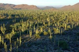
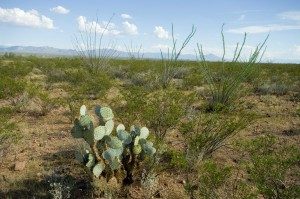
The flora of this desert is largely of southern, tropical origins, and is in many ways a northern extension of thornscrub communities, but with more frost-tolerant species. In western Arizona, a xeric, relatively species-depauperate and low-stature aspect of this community, known as the Lower Colorado River Valley Subdivision of Sonoran Desertscrub, is found in valleys and lower mountains from the Avra Valley westward into California and north to about Needles mostly at elevations of less than 650 m (2,130 ft) and where rainfall is generally less than 20 cm (7.9 in)/year. It is often characterized by low and sparse stands of Creosote (Larrea tridentata) and White Bursage (Ambrosia dumosa) in the valley bottoms, with the arroyos containing a greater density and diversity of plants, including trees such as Ironwood (Olneya tesota), Blue Palo Verde (Parkinsonia floridum), and Catclaw Acacia (Acacia greggii). On bajadas and mountain slopes, vegetation diversity typically increases, and several cacti, Ocotillo (Fouquieria splendens), and a variety of shrubs and grasses not found or only rarely found in the flats make their appearance. Saguaros (Carnegiea gigantea) are relatively scarce and restricted to arroyos or other places that collect rain water.
Found primarily in the eastern and northern Sonoran Desert where precipitation occurs in greater abundance (generally more than 20 cm (7.9 in)/year) is a species-rich and arborescent desertscrub known as the Arizona Upland Subdivision that, in its most diverse examples, can look much like Foothills Thornscrub. This vegetation community extends westward into mountain ranges such as the Kofa and Castle Dome Mountains, but occurs in the valleys as well in the eastern and northern portions of the Sonoran Desert. In the 100-mile Circle it is bordered at its lower elevations by the Lower Colorado River Valley Subdivision, and on its upper end by Semi-desert Grassland. Leguminous trees, such as Foothills Palo Verde (Parkinsonia microphyllum), Velvet Mesquite (Prosopis velutina), Blue Palo Verde, Saguaro, a variety of Cholla (Cylindropuntia), Prickly Pear (Opuntia), and many shrubs, vines, and grasses make up this community type. Trees and columnar cacti are not restricted to arroyo bottoms, although they are most abundant there.
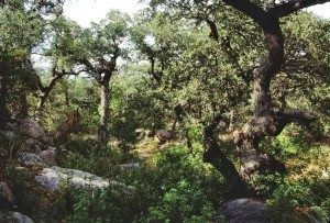
Foothills Thornscrub
This is a strongly drought-deciduous community that lies geographically and floristically between Sonoran Desertscrub and Tropical Deciduous Forest. It is of tropical origins, with many frost-sensitive species. It is also where many tropical amphibian and reptile species have their northern geographical limits (e.g. Boa Constrictor [Boa imperator], Sonoran Spiny-tailed Iguana [Ctenosaura macrolopha], and Sinaloa Toad [Incilius mazatlanensis]). This community is poorly represented in the 100-mile Circle. Brown et al. (2007) show an isolated patch of it just north of Imuris, Sonora; however, its placement in this community type is questionable. The vegetation at that site consists of dense stands of Saguaro with some Organ Pipe Cacti (Stenocereus thurberi) that could probably be categorized as either Foothills Thornscrub or Sonoran Desertscrub. However, there is no doubt that Foothills Thornscrub comes close to if not inside the southern border of the 100-mile Circle, and its influence on the herpetofauna of the Circle is undeniable.
Brown (1982) and Brown et al. (2007) refer to this community as Sinaloan Thornscrub, but most current literature uses the name Foothills Thornscrub (see Martin et al. 1998). When well-developed, this is a tangle of thorny shrubs, cacti, small trees, and vines that for much of the year is largely brown and leafless. Within two weeks of the start of the summer rains, it turns a tropical lush green, and animal life, particularly the herpetofauna and arthropods, quickly becomes quite noticeable. Rainfall ranges from 30-50 cm (12-20 in) annually (41 cm [16 in] at Imuris), with about 70% of it falling during the summer months. In the northern examples, occurrence of Organ Pipe Cactus, Tree Ocotillo (Fouquieria macdougalii), Tree Morninglory (Ipomea arborescens), and Feather Tree (Lysiloma watsoni) are indicators that one has moved beyond Sonoran Desertscrub into Foothills Thornscrub. Babiso Palms (Brahea nitida) occur with Boa Constrictors a bit outside the 100-mile Circle in Magdalena Palm Canyon southeast of Magdalena, a tantalizing and mere 96 km (60 mi) south of the Arizona border.
Semi-desert Grassland
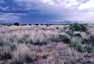
Also known as Desert Grassland, this community ranges in elevation from about 1,100-1,700 m (3,608-5,576 ft), and in the 100-mile Circle is typically bordered by Sonoran or Chihuahuan Desertscrub at the lower elevations and woodland communities at its upper end. It occurs as remnant patches atop some mountain ranges surrounded by Sonoran Desertscrub. Precipitation generally ranges from about 25 to 45 cm (9.8-18 in)/year. Perennial bunch grasses, as well as annual grasses and herbs, originally made up much of the vegetation of this community, although Yuccas (e.g. Yucca elata) and occasional Velvet Mesquite were often visually dominant. However, livestock grazing, fire suppression, and likely other factors have almost universally led to invasion of shrubs, trees, and cacti into Semi-desert Grasslands, so that most stands now appear to be transitional between grassland and desertscrub. Velvet Mesquite, in particular, is considered a damaging invader in Semi-desert Grasslands, and ranchers and conservationists alike have waged expensive, but often unsuccessful, efforts to reduce its abundance. A variety of non-native grasses, most notably Lehmann Lovegrass (Eragrostis lehmanniana), have taken hold in Semi-desert Grassland.
In the 100-mile Circle, Semi-desert Grasslands are found generally on bajadas and lower montane slopes. Grasslands at the Santa Rita Experimental Range and throughout much of the Sulphur Springs Valley are good examples of this community type.
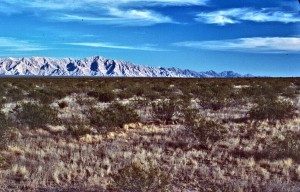
Plains Grassland
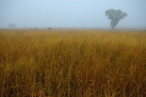
This is a short-grass prairie, a community that is much more common above the Mogollon Rim and northward and eastward into the Great Plains. In the 100-mile Circle, this community is limited to the San Rafael Valley, the upper San Pedro River Valley – primarily in Sonora, and the Sonoita Valley. These sites are at about 1,500-1,700 m (4,920-5,576 ft) elevation where rainfall occurs primarily during the summer and averages 40-55 cm (16-22 in)/year. The flora is dominated by warm season bunchgrasses, such as Purple Three-awn (Aristida purpurea), Grama Grasses (Bouteloua), Plains Lovegrass (Eragrostis intermedia), Sacaton (Sporobolus), Brittlegrass (Setaria), and Vine Mesquite (Panicum obtusum). Hard freezes during the winter inhibit invasion by Velvet Mesquite, cacti, and many shrubs. Juniper and Oak often invade Plains Grasslands from the higher elevations; however, if fire is playing a natural role, tree invasion is not really an issue. Where grazing is heavy (particularly in some areas of Sonora), perennial bunchgrasses may be scarce or limited to species with poor palatability.
Chihuahuan Desertscrub
The Chihuahuan Desert lies mainly east and southeast of our area, but the westernmost examples of this desertscrub are found in the upper San Pedro River Valley. Compared to the Sonoran Desert, this community is cold in winter and dominated by shrubs and grasses. Winter rainfall is scant and undependable, but the summer monsoon is strong. Precipitation varies from about 20 to 30 cm (7.9-12 in)/year. In the 100-mile Circle, Chihuahuan Desertscrub lies mostly between 1,175 and 1,400 m (3,854-4,592 ft) elevation in high valleys and bajadas. It is bordered at its upper elevational limit by Semi-desert Grassland or less commonly, Oak Woodlands. At its lower limits, it may give way to Sonoran Desertscrub. Characteristic plants of Chihuahuan Desertscrub include Creosote, Tarbush (Flourensia cernua), Chihuahuan Whitethorn (Acacia neovernicosa), and Soaptree Yucca (Yucca elata) among others. Small, bush-like Mesquite (Prosopis velutina and P. glandulosa) are not uncommon, and Rose-fruited Juniper (Juniperus coahuilensis) often dots the uplands, with larger individuals along the arroyos. Chihuahuan Desertscrub frequently grows on limestone soils, and rocky, limestone knolls support localized populations of rare or unusual cacti and shrubs such as the Hedgehog (Echinocereus psuedopectinatus), Button Cactus (Epithelantha micromeris), and Rosewood (Vauquelinia californica).
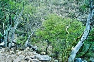
Inland Chaparral
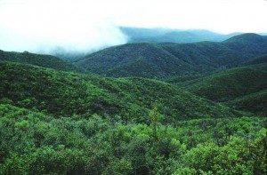 Poorly represented in the 100-mile Circle, Inland Chaparral is a shrub-dominated community much more common to the north and northwest below the Mogollon Rim. Within the Circle, it occurs mostly on western slopes of the Santa Catalina, Rincon, and Galiuro Mountains, on the lower slopes and bajadas of the Santa Theresa Mountains, but also around the ranges to the east and north of Phoenix. It is found mostly from about 1,000-1,850 m (3,280-6,068 ft) elevation. Precipitation is bimodal (winter and summer) and varies from about 38 to 63 cm (15-25 in)/year. Above Inland Chaparral are montane woodlands. Below it are Semi-desert Grasslands or Sonoran Desertscrub. Shrubs of this community tend to be evergreen, with tight, dense canopies; and they are fire adapted, sprouting vigorously from the root crown or from seed after fires, which burn hot in this community. Common species include Shrub Live Oak (Quercus turbinella), Sumac (Rhus trilobata), Silktassels (Garryea), and Mountain Mahogany (Cercocarpus montanus). Openings and rock outcrops within Interior Chaparral may support various grasses, agaves, cacti, and herbaceous plants.
Oak Woodland
 Termed Madrean Evergreen Forest and Woodland by Brown et al. (2007), this community is characterized by stands of oaks that may occur as a savanna amidst grasslands, or as denser woodlands. In the 100-mile Circle, Oak Woodlands are typically bordered by grasslands on the lower elevational limits and Pine-oak Woodland at their upper limits. Common oak species have their origins in the Sierra Madre Occidental and include Emory Oak (Quercus emoryi), Arizona White Oak (Q. arizonica), Mexican Blue Oak (Q. oblongifolia), Silverleaf Oak (Q. hypoleucoides), and Netleaf Oak (Q. rugose). These woodlands often also include Alligator and Rose-fruited Juniper (Juniperus deppeana and J. coahuilensis) and Border Pinyon Pine (Pinus discolor). Oak Woodlands occur commonly from about 1,200 m to 1,800 m (3,936-5,904 ft) or higher on south facing slopes; precipitation ranges from approximately 36 to 63 cm (14-25 in)/year. The oaks in this community are considered evergreen, but in May and June before the rains start, their leaves may turn a burnished orange-brown, and they may shed leaves, much as winter-deciduous oaks turn color and lose their leaves in the fall. This community dominates the slopes of many mountain ranges in southeastern Arizona and northeastern Sonora.
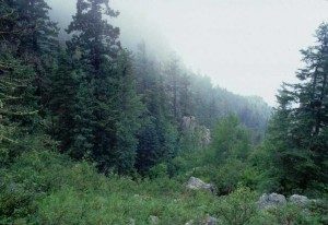
Pine-Oak Woodland
 Above the Oak Woodlands several species of pines are found mingled in with the evergreen oaks, including Arizona Pine (Pinus arizonica), Chihuahua Pine (Pinus chihuahuana), Two-Needle Pinyon Pine (Pinus edulis), Apache Pine (Pinus englemannii), White Pine (P. strobiformis), and Ponderosa Pine (Pinus ponderosa). The deciduous Gambel Oak (Q. gambelii) can be found here, as well. At the higher elevations, evergreen oaks may drop out leaving essentially pine forests with some Gambel Oak scattered through, and other tree species along drainage bottoms. Brown et al. (2007) call this Madrean Montane Conifer Forest, and it occurs mostly above 2,000 m. At about 2,130 m it begins to give way to Mixed Conifer Forest, but Pine-oak Woodland can occur considerably higher on drier, warmer sites such as south-facing slopes. Winters are cold, and precipitation exceeds 50 cm (20 in)/year. This vegetation community only occurs in the higher mountains in the 100-mile Circle, such as the Pinal, Santa Catalina, Santa Rita, Chiricahua, and Pinaleño Mountains, and the Sierras Los Pinitos and Los Ajos. In its natural climax state, Pine-oak Woodland consists of relatively open stands or park lands of large trees, the understory of which is made up of grasses, scattered shrubs, and occasional cacti and Mountain Yucca (Yucca schottii). A history of fire suppression in the Arizona ranges where this community occurs has halted the natural fire cycle that helped create these park-like woodlands. Instead, we now have Pine-oak woodlands with many small trees in the understory that create ladder fuels, allowing what would normally be natural ground fires to spread into the canopy. Most of the ranges in Arizona that support this vegetation community have, as a result, been subjected to massive stand-replacing fires in the last three decades. In Sonora, where fire suppression has not been much of a factor, fire is still playing a natural role, moving through the understory every few years, clearing out underbrush and small trees.
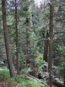
Mixed Conifer and Aspen Forest
This high elevation (mostly >2,135 m [7,000 feet]) forest type is restricted to the tallest mountains within the 100-Mile Circle. Winters are cold and the growing season is relatively short. Precipitation ranges from about 46 to 76 cm (18-30 in)/year. Mature Mixed Conifer Forests are tall and fairly dense. The forest floor is heavily shaded and an accumulation of litter limits understory growth. In the 100-Mile Circle, these forests are dominated by Douglas-fir (Pseudotsuga menziesii), White Fir (Abies concolor), Southwestern White Pine (Pinus strobiformis), and Ponderosa Pine (Pinus ponderosa). As with Pine-oak Woodland, this forest type has been devastated by wildfires over the last three decades in southeastern Arizona. The extent of this forest type is now much reduced in the Santa Rita, Santa Catalina, Huachuca, Pinaleño, and Chiricahua Mountains because of wildfires. Often within the Mixed Conifer Forest are patches, some of them extensive, of Aspen (Populus tremuloides). Aspen forms clonal colonies of trees, connected via common root systems. These trees resprout vigorously after fire and frequently dominate areas of recent fire.
Spruce-Fir Forest
Within the 100-mile Circle, this is a very rare and declining forest type limited to the tops of our highest mountains – mostly above 2,900 m (9,510 feet) and only in the Pinaleño and Chiricahua Mountains. These forests, termed Rocky Mountain and Great Basin Subalpine Conifer Forest by Brown et al. (2007), are wet and cold, averaging more than 63 cm (25 in) of precipitation per year, much of it in the form of snow. The largest area of Spruce-Fir Forest in the 100-Mile Circle occurs in the Pinaleño Mountains and is dominated by Engelmann Spruce (Picea engelmannii) and Cork-bark Fir (Abies lasiocarpa) in the upper elevations, but Douglas-fir, White Fir, Southwestern White Pine, Ponderosa Pine, and Aspen are mixed in as the ecotone with Mixed Conifer Forest is approached. Mountain meadows that in summer become fields of flowers are not uncommon within the Spruce-Fir Forest. This forest type is generally too wet to carry fire. But recent drought and warm winters that have allowed the survival of populations of various forest insect pests to overwinter, have led to many dead and dying trees in the Pinaleño and Chiricahua Mountains and a greatly enhanced susceptibility to fire. Fires have devastated this forest type in the Pinaleño Mountains over the last two decades and the 2011 Horseshoe 2 Fire in the Chiricahuas burned through the small patch of Spruce-Fir Forest there. Recent warm winters and drought in this forest type are consistent with predictions of climate change models. Whether these southernmost, relictual Spruce-Fir Forests can persist in a warmer and drier climate is questionable.
Riparian Woodlands and Aquatic Sites
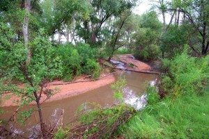 Areas with permanent surface water, high ground water, or frequent intermittent flow support obligate wetland plants. These wetland and riparian systems course through all of the above vegetation communities in the form of streams and rivers or dot them as springs, ciénegas, and playa lakes. Cattle tanks – impoundments along otherwise dry arroyos – sometimes support wetland and riparian plants as well, and can be crucial habitats for some species of amphibians and reptiles. Szaro (1989) described 28 types of riparian woodlands and scrublands in Arizona and New Mexico. In addition, there are many types of emergent and aquatic wetland types.
Perhaps the most notable wetland community in the 100-Mile Circle is the Fremont Cottonwood (Populus Fremontii) and Willow (Salix sp.) forests on the first terrace along major rivers, such as the San Pedro, Santa Cruz, and Gila, and associated second terrace Mesquite Bosques (primarily Prosopis velutina but also Prosopis pubescens in places). In some areas, particularly where the hydrology has been altered, introduced Saltcedar (Tamarix ramosissima) has replaced Cottonwoods, Willows, and Mesquites. Rising in elevation into montane canyons, Arizona Sycamore (Platanus wrightii), Arizona Walnut (Juglans major), Arizona Ash (Fraxinus pennsylvanica), and other trees become more common. At higher elevations still, Box Elder (Acer negundo), Bigtooth Maple (Acer grandidentatum), and various conifers populate stream courses.
In places too wet for trees and shrubs are bogs and ciénegas grown over with wetland plants such as Cattails (Typha sp.), Bulrushes (Scirpus sp.), Sedges (Carex sp.), and other obligate wetland plants. Many of these grow in saturated soils or as emergent plants in bodies of water. These types of wetlands are rare in the 100-mile Circle, and historically, many of them were pumped dry, diverted, or otherwise destroyed by human activities (see Hendrickson and Minckley 1984), and most that remain are still threatened by such activities.
Literature Cited
- Brown, D.E. (editor). 1982. Biotic communities of the American Southwest – United States and Mexico. Desert Plants 4(1-4):3-342.
- Brown, D.E., T.C. Brennan, and P.J. Unmack. 2007. A digitized biotic communities map for plotting and comparing North American plant and animal distributions. Canotia 3(1):1-12.
- Brown, D.E., and C.H. Lowe. 1980. Biotic communities of the Southwest (map). Rocky Mountain Forest and Range Experiment Station, General Technical Report RM-78.
- Felger, R.S., M.B. Johnson, and M.F. Wilson. 2001. The Trees of Sonora, Mexico. Oxford University Press, New York, NY. 391 pp.
- Hendrickson, D.A., and W.L. Minckley. 1984. Cienegas – vanishing climax communities of the American Southwest. Desert Plants 6(3):131-175.
- Martin, P.S., D. Yetman, M. Fishbein, P. Jenkins, T.R. Van Devender, and R.K. Wilson. 1998. Gentry’s Río Mayo Plants. University of Arizona Press, Tucson. 557 pp.
- Szaro, R.C. 1989. Riparian forest and scrubland community types of Arizona and New Mexico. Desert Plants 9(3-4):69-138.
[/vc_column_text][/vc_column][/vc_row]